In last two weeks I was testing a GPS device that I bought to use with maemo-mapper on my inter-states trips.
Here in my city (Curitiba – Paraná – Brazil), maemo-mapper works very well…. My car is always in the route ( a green line in maemo-mapper ), I know perfectly where streets are, and I know exactly where take the exits on the highways. But Curitiba is a big and important city, so I decided to test it in Londrina – PR.
Londrina is a little country tow here in Paraná, but probably is the second more important city in my state. Anyway, how I was saying writing before, GoogleMaps is so faw away to be precise in Londrina. Take a look in the photo below:
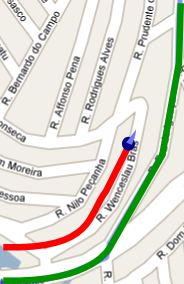
The red line is what my car was doing and the green line is what GoogleStreetMaps was telling me to do.
Now I know; it’s not a Google’s problem, but it’s a MapLink problem. Maplink is the company who provides street-maps to google in Brazil.
Anyway, on this situation, I can’t trust in maemo advises anymore. Google’s way points doesn’t work anymore. So I decide to fix this problem writing a “mapper-calibration” feature inside maemo-mapper. And its ready now.
Go to “Menu/Maps/Map Calibrate“. After that, just click in a point that you think you really are.
I sugest you to stop your car in some corner, find this corner in mapper, and click on it. It’ll be more precise.
And the result will be something like that:
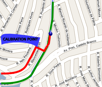
Há! Much better now!
I don’t know if this problem happens in another countries too, but if you think that this feature is interesting to you, you can download the patch here, or get the compiled package. (2008-version only, sorry folks)
Just remember to disable this feature when you don’t need it. =)
So, on the next weekend I’ll be in Sorocaba testing this feature. Then I’ll describe if this is useful.
So, nice weekend for everyone!
Bye!
[update: 19/01/2008] BTW, I was forgotting. Maemo-Mapper is very well developed. They have a nice (and interesting) unit-system, so its very easy to transform pixels into latitude/longitude and vice versa. Congratulations Maemo-Mapper’s Team!
6 Comments